| Build Thread, Page :
<< 17 18 19 20 21 22 23 24 25 (490 posts, 20 posts per page, 25 pages in total)
|
[ < Prev ] [ Next > ] |
| JohnG., Comment for image # 24011 | 05 Nov 11 12:35 |
| Whoa...great shots. |
| David Duckett, Image # 24011 | 05 Nov 11 10:45 |
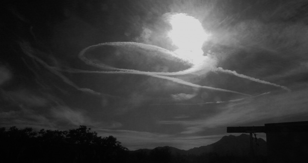
With the red filter |
| David Duckett, Image # 24010 | 05 Nov 11 10:42 |
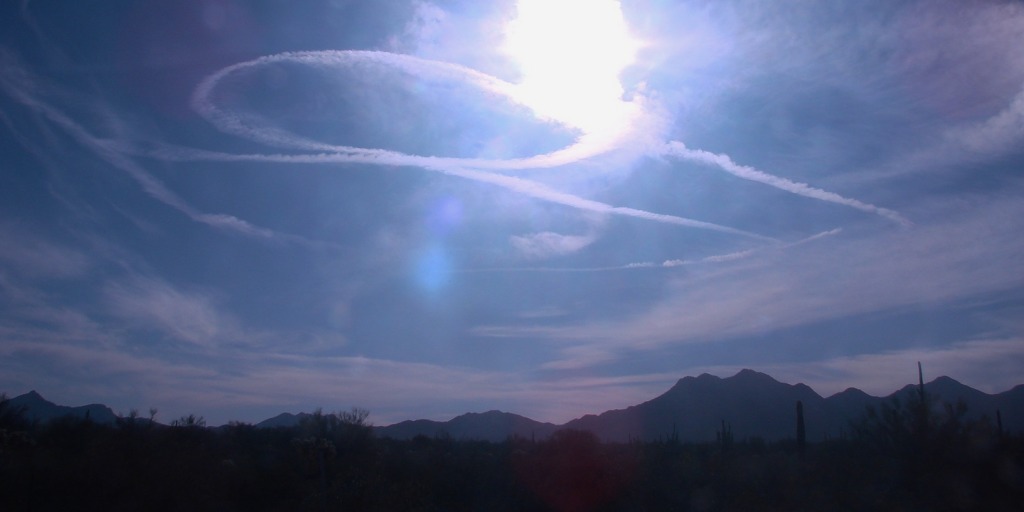
Dogfight! |
| David Duckett, Comment for image # 24000 | 04 Nov 11 03:43 |
| Internet |
| John M Oshust, Comment for image # 24000 | 03 Nov 11 21:36 |
| Is this one of your books??? Super duper if it is! |
| David Duckett, Comment for image # 23938 | 03 Nov 11 16:23 |
| And it still works. |
| Creosotewind, Comment for image # 23938 | 03 Nov 11 15:49 |
| David, I went to the Egypt show at the Phoenix Art Museum several years ago. They had several sections of carved stone to show the hieroglyphics. Great carving! But the real interesting pieces were the unfinished pieces. Those still showed the pounce patterns where the drawings were traced and perforated and then a powder was pushed through the perfs. Just like we used to draw patterns when I was in the sign business.
I've seen old masters paintings where they used the grid technique. Some even made frames with string grids that they would prop up so they could paint landscapes or still lifes. What's old is new. |
| Brian Kostecki, Comment for image # 23955 | 31 Oct 11 21:44 |
| Or a moving company, Chip, Nick, and Rob. |
| John M Oshust, Comment for image # 23955 | 31 Oct 11 20:48 |
| Great name for a law firm. Almost as good as Dewey, Fleasum, and How. |
| pfinn, Comment for image # 23955 | 31 Oct 11 19:27 |
| Wynkin, Blinkin and Nod. |
| jgood, Comment for image # 23952 | 31 Oct 11 13:02 |
| http://itunes.apple.com/gb/app/plane-finder/id336477530?mt=8 |
| jgood, Comment for image # 23952 | 31 Oct 11 13:00 |
| :) I asked because I have an iPad app which shows (in real-time) the tracks of aircraft going over. It works in Europe, but not the US, I believe). It's very cool though, you can see something in the sky, and see exactly where it's going, altitude, tail number, etc. |
| David Duckett, Comment for image # 23952 | 31 Oct 11 08:55 |
| Binoculars ;-) |
| jgood, Comment for image # 23952 | 31 Oct 11 08:46 |
| How could you identify that 737? |
| David Duckett, Image # 23952 | 31 Oct 11 06:48 |
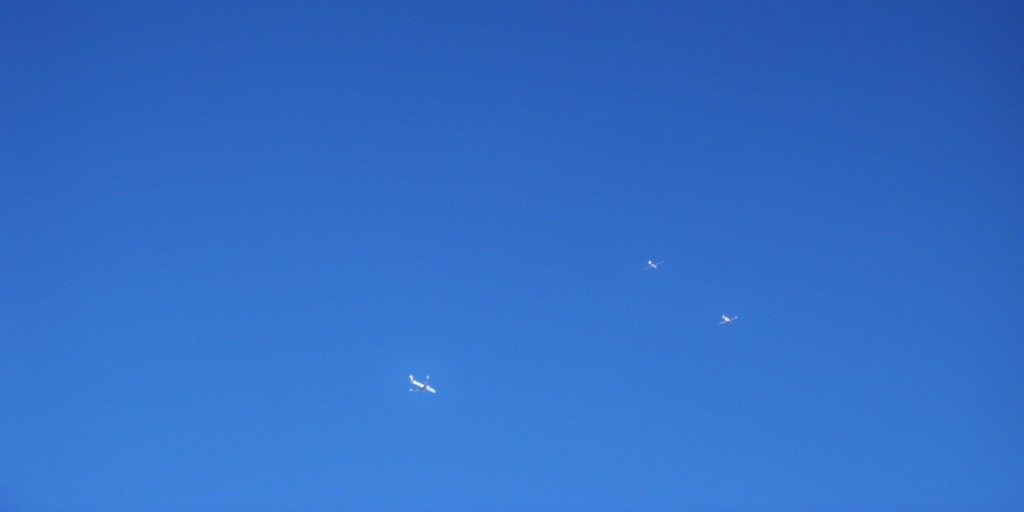
An Alaska Airlines 737 on approach to Tucson International and a tow plane and glider from El Tiro Glideport, 4 miles away. |
| David Duckett, Comment for image # 22776 | 22 May 11 15:33 |
| For more info, type DC-130 into your search engine. It was a long time ago. |
| David Duckett, Comment for image # 22776 | 22 May 11 15:06 |
| Our system was called Microwave Command Guidance Systems. There was a radar tech and an officer using what was basically a control stick. The movement of the stick caused different commands to be sent and the track was plotted on a board in front of the operator. No video. We had the same system on the ground here which could control the drones if the A/C lost them. In Korea, the ground site controlled the drone. On one memorable occasion, the track being plotted showed a giant phallic symbol, with attachments, pointed towards the coast of China. Since they were tracking the drone, too, I always wondered what their reaction was. |
| jgood, Comment for image # 22776 | 22 May 11 14:49 |
| So these were radio controlled? How did the operator fly them? I take it there was no remove video view for the operator in those days? Just some telemetry readings? And they just piloted them back to a safe area, and deployed a parachute to land them again? Cool stuff! |
| David Duckett, Comment for image # 22776 | 22 May 11 04:46 |
| The drones were also used for electronic counter measures. Additionally we had a site in Osan, Korea and from there the drones were flown off the coast of China where they gathered and sent back radio transmissions. The drones were recovered by Jolly Green helicopters which snagged a deployed parachute. |
| David Duckett, Image # 22776 | 22 May 11 04:16 |
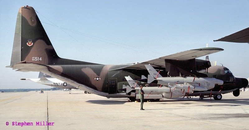
This is a DC-130A carrying four Ryan drones. The photo was taken on Davis-Monthan AFB, Tucson, by a guy who was on my crew at the time. We had Automatic Tracking radar gear on board which was used to fly the drones and my crew helped maintain it. This was 1974-1978. The drones were used in Viet Nam to take photos and who knows what else they did. |
| Build Thread, Page :
<< 17 18 19 20 21 22 23 24 25 (490 posts, 20 posts per page, 25 pages in total)
|
[ < Prev ] [ Next > ] |
